![](/images/other/stat-length.png)
![Excursión Senderismo Sarroux - Saint-Julien - Un air de montagne - Sarroux - Photo](https://media.geolcdn.com/t/1900/400/ext.pjpeg?maxdim=2&url=https%3A%2F%2Fservices.sitytrail.com%2FGeolivesWS%2FDownloadMedia.ashx%3FTrailID%3D318091%26Media%3D17549_2.jpg)
Un air de montagne - Sarroux
tracegps
Usuario
![Longitud](/images/other/stat-length.png)
![Altitud máxima](https://static1.geolcdn.com/siteimages/upload/files/1508320355ic_sort_altitude_max_24dp.png)
![Desnivel positivo](https://static1.geolcdn.com/siteimages/upload/files/1508320355ic_sort_den_pos_24dp.png)
![Km-Effort](/images/other/stat-length.png)
![Altitud mínima](https://static1.geolcdn.com/siteimages/upload/files/1508320355ic_sort_altitude_min_24dp.png)
![Desnivel negativo](https://static1.geolcdn.com/siteimages/upload/files/1508320355ic_sort_den_neg_24dp.png)
![Boucle](https://static1.geolcdn.com/siteimages/upload/files/16400158638029165_repeat_loop_refresh_sync_direction_icon.png)
![Senderismo](https://static1.geolcdn.com/sitytour/trail-icons/101.png)
4h30
Dificultad : Medio
![Escanee este código QR para abrir la excursión en la aplicación SityTrail](https://capi.geolives.com/qq0zvz2zws4bq2lad0pu/sitytour/trails/318091/qr.png?size=200)
Aplicación GPS de excursión GRATIS
A propósito
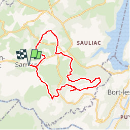
Ruta Senderismo de 16 km a descubrir en Nueva Aquitania, Corrèze, Sarroux - Saint-Julien. Esta ruta ha sido propuesta por tracegps.
Descripción
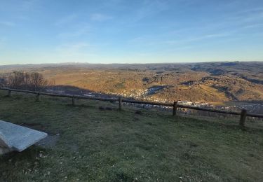
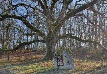
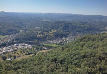
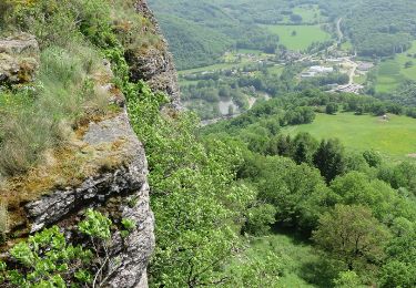
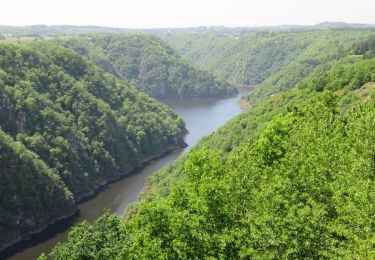
Vous êtes ici au sein de la commune la plus élevée du Plateau Bortois. Pour commencer, arpentez le coquet village de Sarroux. Après cette balade en douceur, entamez l'ascension du point culminant de la commune : le puy de Bort (859m). Vos efforts seront récompensés par le plus beau point de vue sur les deux géants auvergnat du Puy de Sancy et du Puy Mary. La fin du parcours laisse place à l'histoire avec les deux frères ennemis des châteaux de Val et de Pierrefitte, qui dressent fièrement leur tour l'une face à l'autre avec la Dordogne pour frontière. Téléchargez la fiche du circuit sur le site du Tourisme en Limousin.
Localización
Comentarios
Excursiones cerca
![Excursión Senderismo Sarroux - Saint-Julien - La Pyramide, le château Pierrefitte, les Orgues - Photo](https://media.geolcdn.com/t/375/260/ext.jpg?maxdim=2&url=https%3A%2F%2Fstatic1.geolcdn.com%2Fsiteimages%2Fupload%2Ffiles%2F1553511878bg_sport_marche.png)
![Senderismo Senderismo](https://static1.geolcdn.com/sitytour/trail-icons/101.png)
Senderismo
![](/images/other/stat-length.png)
![](https://static1.geolcdn.com/siteimages/upload/files/16400158638029165_repeat_loop_refresh_sync_direction_icon.png)
![Excursión Senderismo Bort-les-Orgues - Tour des orgues à Bort les Orgues - Photo](https://media.geolcdn.com/t/375/260/5b1c5c81-36dc-41c4-864c-ecbcff7d2e43.jpg&format=jpg&maxdim=2)
![Senderismo Senderismo](https://static1.geolcdn.com/sitytour/trail-icons/101.png)
Senderismo
![](/images/other/stat-length.png)
![](https://static1.geolcdn.com/siteimages/upload/files/16400158638029165_repeat_loop_refresh_sync_direction_icon.png)
![Excursión Senderismo Bort-les-Orgues - Les Orgues de Bort Les O. - Photo](https://media.geolcdn.com/t/375/260/0a5e481c-a64a-4225-ac0e-0a1a4f276c56.jpg&format=jpg&maxdim=2)
![Senderismo Senderismo](https://static1.geolcdn.com/sitytour/trail-icons/101.png)
Senderismo
![](/images/other/stat-length.png)
![](https://static1.geolcdn.com/siteimages/upload/files/16400158638029165_repeat_loop_refresh_sync_direction_icon.png)
![Excursión Senderismo Bort-les-Orgues - Les Orgues - Photo](https://media.geolcdn.com/t/375/260/de45ad4a-de77-4e58-a4e0-285397248ea6.jpg&format=jpg&maxdim=2)
![Senderismo Senderismo](https://static1.geolcdn.com/sitytour/trail-icons/101.png)
Senderismo
![](/images/other/stat-length.png)
![](https://static1.geolcdn.com/siteimages/upload/files/16400158638029165_repeat_loop_refresh_sync_direction_icon.png)
![Excursión Senderismo Sarroux - Saint-Julien - le site de Saint-Nazaire - Photo](https://media.geolcdn.com/t/375/260/5f0b677a-852b-4fdc-8074-c6913b286b71.jpg&format=jpg&maxdim=2)
![Senderismo Senderismo](https://static1.geolcdn.com/sitytour/trail-icons/101.png)
Senderismo
![](/images/other/stat-length.png)
![](https://static1.geolcdn.com/siteimages/upload/files/16400158638029165_repeat_loop_refresh_sync_direction_icon.png)
![Excursión Senderismo Bort-les-Orgues - tour des orgues - Photo](https://media.geolcdn.com/t/375/260/24738bfa-8550-482e-ace9-5bec2f2943d4.jpg&format=jpg&maxdim=2)
![Senderismo Senderismo](https://static1.geolcdn.com/sitytour/trail-icons/101.png)
Senderismo
![](/images/other/stat-length.png)
![](https://static1.geolcdn.com/siteimages/upload/files/16400158638029165_repeat_loop_refresh_sync_direction_icon.png)
![Excursión Senderismo Bort-les-Orgues - 20210613 Bort Les Orgues - Photo](https://media.geolcdn.com/t/375/260/5cf5811b-6fd8-47ab-a075-2de14622bbb5.jpg&format=jpg&maxdim=2)
![Senderismo Senderismo](https://static1.geolcdn.com/sitytour/trail-icons/101.png)
Senderismo
![](/images/other/stat-length.png)
![](https://static1.geolcdn.com/siteimages/upload/files/16400158638029165_repeat_loop_refresh_sync_direction_icon.png)
![Excursión Senderismo Bort-les-Orgues - Bort-les-Orgues - Photo](https://media.geolcdn.com/t/375/260/ext.jpg?maxdim=2&url=https%3A%2F%2Fservices.sitytrail.com%2FGeolivesWS%2FDownloadMedia.ashx%3FTrailID%3D422569%26Media%3De1514a53-c7b6-4b0e-9e57-15f5c0a97564.JPG)
![Senderismo Senderismo](https://static1.geolcdn.com/sitytour/trail-icons/101.png)
Senderismo
![](/images/other/stat-length.png)
![](https://static1.geolcdn.com/siteimages/upload/files/16400158638029165_repeat_loop_refresh_sync_direction_icon.png)
![Excursión Senderismo Sarroux - Saint-Julien - Saint-Julien-près-Bort - Photo](https://media.geolcdn.com/t/375/260/ext.jpg?maxdim=2&url=https%3A%2F%2Fservices.sitytrail.com%2FGeolivesWS%2FDownloadMedia.ashx%3FTrailID%3D422568%26Media%3D8858e287-aa9d-42f8-8581-e582772f882a.JPG)
![Senderismo Senderismo](https://static1.geolcdn.com/sitytour/trail-icons/101.png)
Senderismo
![](/images/other/stat-length.png)
![](https://static1.geolcdn.com/siteimages/upload/files/16400158638029165_repeat_loop_refresh_sync_direction_icon.png)
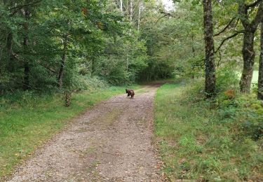
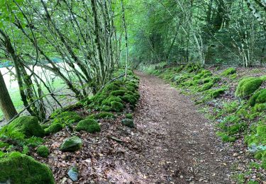
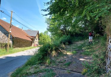
Un très bel assortiment de champs, prairies, bois et forêts exploitées, sur pistes, sentiers et chemins goudronnés. L'essentiel de l'effort est en début de parcours.